- Follow us
Ouachita National Forest
- Attractions
- Ouachita National Forest
Rich in history, the rugged and scenic Ouachita Mountains were first explored in 1541 by de Soto's party of Spaniards. French explorers followed, flavoring the region with names like Fource La Fave River. It was the French that named the area Ouachita - which was the tranlation of the Caddo word "washitah", meaning "Good Hunting Grounds".
The Ouachita National Forest is the oldest National Forest in the South, created December 18, 1907 by President Theodore Roosevelt. It is comprised of 1,647,214 acres with 255,471 acres in Oklahoma and 1,391,743 acres in Arkansas.
There are 35 developed recreation areas, 7 scenic areas, 43 vistas, 5 float camps, 11 shooting ranges, 2 historical sites, 6 wildernesses, 1 national recreation area, and over 700 miles of trails.
Sugar Creek Multi-Use Trail
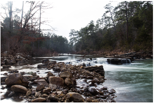
The Sugar Creek Multi-Use Trail is a network of looping trails that winds over various types of terrain and through a variety of tree types. Connecting loops offers users an opportunity to explore exciting outdoor opportunites. The Sugar Creek Mutli-Use Recreation Trail offers motorcycle, 4-wheeler, utility vehicle, horse, bicycle, and foot travel enthusiasts approximately 30 miles of rustic, scenic, historic and picturesque travel ways. The difficulty level ranges from easy to more difficult, with most of the trail being easy to moderate difficulty.
Total trail length is 36.7 miles. Loops range from 2 hours to all day. The trail is unsurfaced, however, some parts where the trail follows roads are graveled. The trail markings consist of yellow rectangles. Markers are posted at intersections to keep you on the trail.
Fees: No Fee. Difficulty Level: Easy to More Difficult
More InformationJack Creek Recreation Area
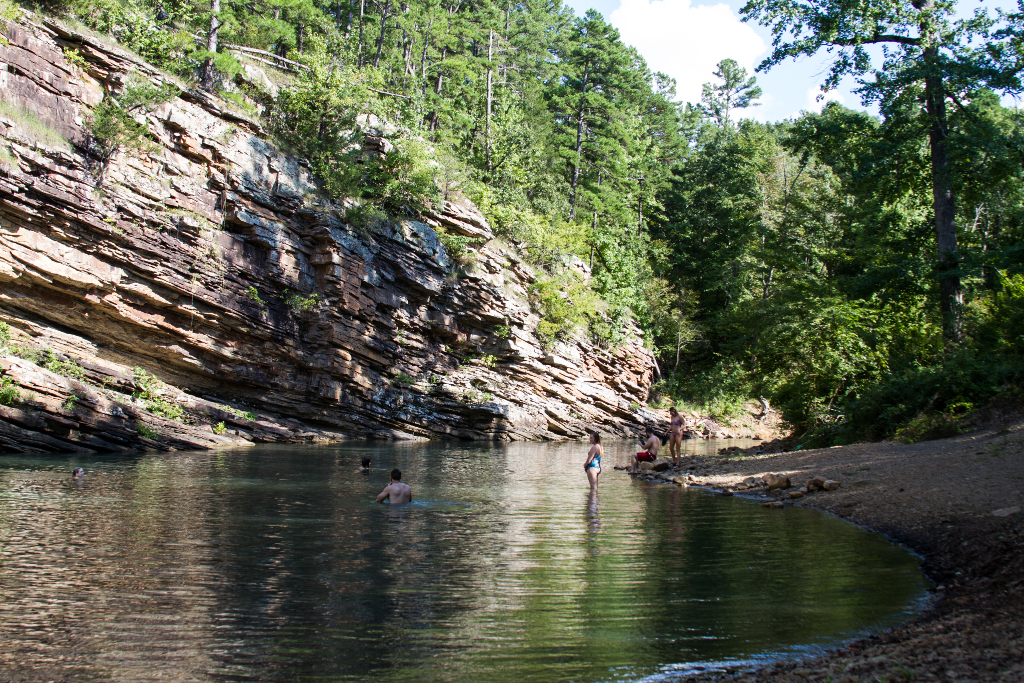
Jack Creek Recreation Area is located in front of towering rock bluffs beside Sugar Creek. The area was constructed in the 1930's by the Civilian Conservation Corp (CCC) and displays several unique, historic facilities, including the National Historic Bath House. There is a short trail that climbs a couple of hundred feet to a recently restored rock overlook. Jack Creek offers day-use and a primitive campground at no cost. Also at Jack Creek Recreation Area is a trailhead for the Hole-In-The-Ground Mountain Hiking Trail and Sugar Creek Hiking Trail. Hole-In-The-Ground Trail is not a loop trail and extends approximately four miles in length. The Sugar Creek Hiking Trail extends approximately three miles connecting Jack Creek to Knopper's Ford Recreation Area.
More InformationKnopper's Ford Recreation Area
Knopper's Ford, situated along Sugar Creek is a day use facility built by the CCC. It is accessible by passenger car or low clearance vehicle. Knopper's Ford is popular with Off Highway Vehicle (OHV) and Equestrian enthusiasts, as it is a very short distance from the fabulous Sugar Creek Multi-Use Recreation Trail. Knopper's Ford offers a remote, semi-primitive experience with limited amenities. It does not have potable water but does have toilet facilities.
More InformationDry Creek Wilderness
Rock formations, wildlife and scenic vistas are a few of the treasures found in Dry Creek Wilderness. This steep and rugged area is protected and managed to preserve the natural conditions, keeping human impact to a minimum.
More InformationKingdoodle Knob and Waldron Breeding Bird Survey
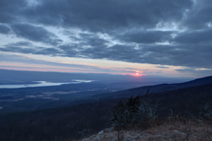
Kingdoodle Knob is a scenic point overlooking the Ouachita National Forest Landscape. White Oak Mountain, Bee Mountain, Petit Jean Mountain and Sugar Creek form the landscape for the annual Waldron Breeding Bird Survey, which is a cooperative venture by the Forest Service and the US Fish and Wildlife Service.
Examples of birds there include chats, bobwhite quail, prarie warbler and blue-gray gnatcatcher. Open mixed pine and hardwood forest include eastern wood-pewee, white-breasted nuthatch, and great crested flycatcher. Birds found in the riparian forest along Sugar Creek include Kentucky warbler, Acadian flycatcher, hooded warbler, and Louisiana waterthrush. The mature hardwood-dominated uplands of Petit Jean Mountain includes ovenbirds and scarlet tanagers. The road passes by Hogan Mountain walk-in turkey hunting area and the Dry Creek Wilderness. This is an area where there is an opportunity to find cerulean warbler along the northeast-facing slopes with a mature hardwood canopy. Do be aware that Black Bear are sometimes seen along this road.
The Waldron Breeding Bird Survey route begins on Forest Service road 20, just off US 71 north of Waldron (Point A). Jsut past Round Mountain, take road FS 178 through Sugar Creek bottoms (B). Just beyond the bottoms, take FS 51 that climbs Petit Jean Mountain toward Kingdoodle Knob (C) and Dry Creek Wilderness (D). Much of this road system is completely accessible by vehicles with adequate clearance, but the road up Petit Jean Mountain can be tricky, especially in wet weather. The road that separates Hogan Mountain from Dry Creek Wilderness (FS 51) passes through hardwood and mixed forest. Heading north on FS 51 toward Booneville, the road leaves the National Forest, entering private lands with small farms -- painted bunting, lark sparrow, blue grosbeak, and roadrunner occurs in this area.
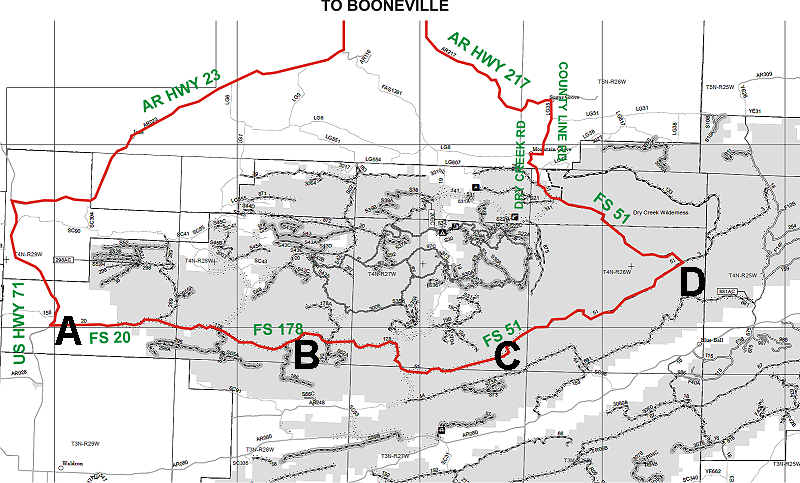
A great day trip would involve starting at Booneville, then heading south-west on AR Hwy 23 and US Hwy 71 to take the survey route (A-D), then heading northwest on US Hwy 217 to complete the loop back to Booneville.